
The Sacred Laguna de Iguaque (Lake Iguaque) is a high altitude Andean lake surrounded by stunning páramo. The Muiscas, the indigenous peoples from the region, believed that humanity originated from the lake when the Goddess Bachué who appeared from the lake with a baby in her arms. The 14 kilometre hike starts in the green valleys of the Bogota Savannah and upwards through cloud forests which slowly let way to lush mountains giving you a panoramic view of the surrounding area. A three hour dive north of Bogota the hike necessitates staying in the beautiful colonial UNESCO World Herritage town Villa de Leyva for at least one night, which is perfect, as the culinary delights are a treat to feast upon the night before and to reward yourself with cold beers and delicious food the night after.
In other blogs there was talk of camping and even a hostel in the park. I can confirm that when we went in December 2019 there was no provision for staying on site and the restaurant was closed. We could see the facilities but they were closed. If it is you intention to camp on site check that this is operating before you go. If you hear that the camping is open again please leave a comment so I can update this message.
For other hikes which you can combine with a weekend getaway take a look at my guides to Cerro Quininí, where the temperature is much warmer than Bogotá and you can relax in the surrounding coffee farms. Or head to Parque Natural Chicaque and spend the weekend camping, or relaxing in the hotel, while hiking,bird watching or horse riding.
Information
- Our Experience
- From Bogota to Villa de Leyva
- How to Hike to Laguna de Iguaque
- Equipment to take
- How to Hike to Mirador El Santo

Our Experience
Angela came home excited one evening after having spoken to her work colleagues about our hiking they recommended the trail to Laguna de Iguaque. I happily added it to the growing list of hikes but as it required an overnight stay and we were in the middle of rainy season we held off. With our relocation to Buenos Aires fast approaching I selected this as one hike that I wanted to try and it payed off as it has to be the most beautiful hike I’ve taken with Angela.
The hike is 14km by road north of Villa de Leyva. There is one bus that leaves the town at 7am each day and if you are driving make sure you arrive before 10am or you will not be permitted to hike. Villa de Leyva is 3 hours north of Bogotà which makes it tricky to get there and back in one day unless you want to wake up at around 2am. We decided to make a longer trip and go up the day before, returning to Bogotà the same day as the hike. Although I’d recommend staying longer if you can as there are plenty of things to do in Villa de Leyva and it will give you the opportunity to relax after a had days hike.
We arrived at Terminal Norte in Bogotà a little before 10am. We were hiking the next day so decided to take things easy, having dropped our son of at his abuelos. Again we arrived via Uber, I was pretty happy with this transport choice as Bogotà is not the easiest city to leave, for all the wrong reasons, and we had fallen into that trap far too many times. And that day we saw what can only be described as a Transmileno tail back as due to someone parking their car upside down in the middle of the bus lane. But on a normal day you can get there easily on the Transmileno. There were three bus companies that go to Ville de Leyva from this terminal and we opted for Libertadores as their bus left next at 10:30 so we booked passage on that.
It turned out the bus was more of a mini-van than a bus and the driver must have needed the bathroom and the closest one was located in Villa De Leyva because that is how he drove. I had the fortune to sit in the back and spent half of the journey in the air as each bump was amplified. Angela sat up front which was less bumpy but the location of here seat meant she couldn’t see out of the windows, which was fine on the freeway, but not helpful when we were driving around tight curvy mountain roads as if replicating the car chase in Quantum of Solace. She was a little car sick when we arrived.
Our hostel was close to the bus terminal and as soon as we started walking we could see why the special town is a world heritage site and it is surrounded by mountains. Straight away I made a mental note of which ones I wanted to climb, all of them.

We dropped our bags and then went in search of places to eat. Just check Tripadvisor as there are some expensive duds but food in this town is a delight. I wanted a decent sandwich so we headed to Entrepanes, a French restaurant specialising in sandwiches. They are expensive compared to Colombian prices but they are delicious. Service was typically slow, French combined with Colombian does not combine well for speed, but its the end result that counts.


We ordered Roast Beef and Pork. They were hot and the meat was tender and delicious. There is also a good range for vegetarians so put this on your list of places to visit.

Afterwards we had a quick tour of the city as this would be the only real time we had to see it in daylight due to the hike the following day. We didn’t spend long as I wanted to hike up to Mirador El Santo, tomorrows challenge was not enough.


Mirador El Santo
There is a statue of Jesus on the mountain above the town. I had read about it in the blog and the receptionist at our hostel was quick to point it our as one of the local sights. From the trail head the path is 1km to the statue and then 1km to return to the town. We were told that it would take about 2 hours for a round trip but Maps.me said 45 minutes each way and I’m always keen to beat the times, however there is one caveat… the entire path is uphill and its a fairly steep climb. However we had at least 7km of up tomorrow so I wanted to give it a go. We left the hostel around 4pm which is leaving things a little late as the sunsets around 6pm in Colombia. The path starts on Calle 12, you can see it clearly marked on maps.me. You need to walk through the football pitch before you can head up. Seeing this and me happy as its good locals still have parts of the town left for themselves and they don’t have to share everything with the tourists.


The photo below was taken right at the beginning so you can see the up begins right form the start. you begin by going through the trees and soon you climb above them.


Unusually for Colombian hikes with Angela around it was sunny, between the clouds and it became hot pretty quickly. We negated to bring water so don’t make the same mistake as us.

As you go up up get more and more beautiful views of the town.

And also the statue appears.


With maybe a third left of the climb the path turns to rock and gets a little steeper. The plants turn to grasses and its quite challenging to walk on, especially going down.


Angela was still feeling a little sick from the bus so decided to sit out the final part of the climb, but never one to let tiredness get in the way of a decent photograph I decided to press on. And very soon the statue appeared again. After a fair scramble over the rocks the path levelled out and became an easy walk for the last hundred metres.

And then as if someone was watching the sun shined though the clouds.


There was a sign politely requesting that visitors stopped at this point. There is a route on maps.me that will take you further up the mountain. I don’t like to invade natures space I decided to stop and rest before heading back down to Angela. By now the sun was also setting and without a torch I would not have gotten far. The whole trip took us around 90 minutes, but we didn’t stay around for long at the top. Going down was much faster and easier, although the exposed rock did slow me down as I didn’t want to fall in this section.


After we headed back to town we wanted to buy supplies for the next day. There is a D1 and an Ara along with a whole host of local shops. We also found the Astral bakery which bakes delicious bread, another rarity in Colombia, to make sandwiches for the next day. They do a whole range of backed good and are located on Calle 12, near the main plaza, or just keep walking straight when you return from El Santo, and are well worth a visit.

It was soon dark with a beautiful sunset, I actually regret not waiting for in on the mountain as there were a few people going up, but I didn’t have a torch and would not have wanted to return in the dark. Instead we went to the main square to look at the Christmas lights.


On the way back to the hostel we noticed a little restaurant called Comida Corena tucked away on Carrera 7. Intrigued we googled and it had excellent reviews so we decided to make it our destination for the night. Its a tiny restaurant with about 5 tables and was busy when we arrived. We took a little walked around town and returned to an empty table that had been saved for us. The restaurant is run by a Korean woman and her Colombian husband. She does all the cooking and he is the waiter and does everything else, they both seem lovely and the food is devine. Its interesting as Angela has noted several times with husband and wife teams in Colombia where the woman does all the work and the husband just takes the money but here it was definitely a team effort. They were both so polite and after talking to them we found out they wanted to keep it small as they felt the size of the restaurant was manageable. The menu is small but is was all chopped and cooked fresh in front of us. To be honest you are doing yourselves a disservice if you don’t come here at least once during your trip.


We returned to the hostel, which had been empty all day, and was now bustling with people getting ready to party. It was here that I had realised my error of forgetting ear plugs which was something I would regret a lot over the course of the night. The room was hardly soundproof, not that I’m complaining, and the town itself is known as a party town. Angela had been a few times and remembers being pretty drunk in the main square for the Kite Festival. So what should we really expect? And our fellow guests did their best to be quiet but to be honest drunk people trying to be quiet is about as successful as my 5 year old son attempts to be a professional ninja on the walk home from school. Actually he has an equivalent ability of attempting to sneak and whisper at any time of the day. So I didn’t get much sleep that night which was not ideal ahead of the hike the next day.

Laguna de Iguaque
The Laguna de Iguaque is located within the Páramo Iguaque, one of Colombia’s many national parks. This area is protected and the rare páramo is what supplies water to Bogotá. This unique landscape only found at high altitude is particularly sensitive, important and carefully guarded. There is one official path into the reserve, although I’ve read and been told there are others, but people the park is protected for a reason and one trail is more than enough for us humas who have now cultivated 70% of the planets surface to leave the rest to nature. There is a restriction on the number of visitors but you will be fine to just turn up as there were only around 20 people hiking they Saturday that we went. I imagine it is less in the week.
The best time of year to hike is outside of the rainy season either in December – March June – September. You can try in rainy season but the ground was pretty wet for us in places and I’ve read some horror stories about the rain in some blog posts. The park is open 8am – 5pm and you need to begin hiking before 10am. Which is not a problem if you take the bus. The bus leaves from the main station at 7am everyday, when its mostly full and costs $4000 each way. You will be dropped off on the main road and it adds 2.5km to you hike each way. The caveat is also that you need to return to the road by 4pm to catch the bus back to town, otherwise its a long walk. You can pay for your return journey in advance to ensure there is a seat for you on the way back. On the way there some people tried to flag the bus on the main road but were refused passage as it was already full.
A lot has been made of the difficulty of the hike, while I appreciate that some people might have had much more extreme weather than we did on the day, this is not a difficult hike. I would say it say 3 out of 5 or a 3.5 at most based on my experience. Yes, its all uphill and the last third is steep, at high altitude, and hard its no where near as scary or as the route we took at Farallones de Sutatausa. While I appreciate that you need to be reasonably fit and that the hike is not for all but scaring hikers and putting them off before they start is not a good idea. I wouldn’t do the hike if you are overweight, unfit, have a broken leg, are under 5 or are elderly…although I did read a post from a guy in his 70s who completed it so who knows. I mean its a challenge, an enjoyable one that is not easy but its not climbing a vertical rock face which is how it was sold to us.
We were dropped on the corner of the road to the entrance to the park at around 7:40. There were 4 other hikers on the bus which was reassuring. Two of them were pretty fit and were soon far ahead and two were not so fit and ended up behind. It was largely a clear day at this stage and starting to get hot. Its 2.5km to the main entrance and I felt the pressure of time. Which is something else which affected us on this hike. Having to be back by 4pm, as you feel that you are under constant pressure to move. We pressed ahead as fast as we could but in reality you have a decent amount of time to take breaks, especially at each numbered part of the trail. Also note there is nothing to buy in the park, so make sure you bring plenty of food and water.

The first part of the hike takes place on a small road.

And you begin to see the mountains, and yes you will be going up to the top there somewhere.


Around where this photo was taken you will see a small store which sells you insurance. I thought it was a con but Angela insisted so we brought it. Turns out she was right as they asked for it when we reached the park. The insurance was around $6000 pesos per person. This is the only place you can buy supplies, but there is no guarantee it will be open so I’d bring everything you need from the town.


The path here was beautiful and is well worth the extra walk. Those in cars don’t get to experience it.


We reached the entrance by around 8:20am and I was happy with progress. Angela had been feeling sick and was lacking energy all along the road, which worried me as that was the easiest part of the hike. I, perhaps selfishly, tried to persuade her to stop here but also didn’t want to deal with an emergency higher up the mountain, but she insisted on going as far as she could. And actually completed the trail without slowing us down.
We had to chat with the park ranger, pay the entrance fee and then attend a safety announcement which took around 20 minutes. The cost is $18000 for nationals and $52000 for gringos. You can find up to date prices for all Colombia’s parks here. There are flushing toilets so make sure you take advantage of them as they will be the last you will see until you return to this point. Also the hike is broken down into numbered sections. This works quite well until you reach section 7, which is the part where they say many people quit and return, but after that I didn’t see any signs after this point. Its in the run up where this becomes important. Here is a map of the hike.

We began hiking from the main entrance at around 8:40am and section 1 of the hike is along this stone path. Its actually not particularly nice to walk along and can be slippery so be careful. You soon cross a stream which you will hear and come close to many times on the hike. The water is safe although we did not sample it and it might be worth taking this opportunity to stock up on supplies.


After a decent amount of time hiking through the forest you will come out in this clearing where there was a hostel and restaurant. Everything had long been closed although the buildings were kept in good condition, so they may well reopen in the future.


Soon after you enter the forest you will see the sign for section two. Its all uphill and sections two, three and four roll into one. They are not too long and vary from steep uphill, to flat to going downhill, which is always annoying when you have spent a lot of effort going up and know you will have to climb again. There is not much down so enjoy it while you can.

The path is pretty safe, and although muddy in places was mainly dry when we hiked. It does get close to the edge of the mountain in places but there is nothing crazy. Just the relentless up. Also I always find that hikes go more slowly in the forest. You think you have walked a kilometre and its only 200 metres. There is nothing to judge the distance against. Make sure you stop for a few minutes at each sign to get some rest, it will help rejuvenate you. Just watch out for section five which is particularly long.

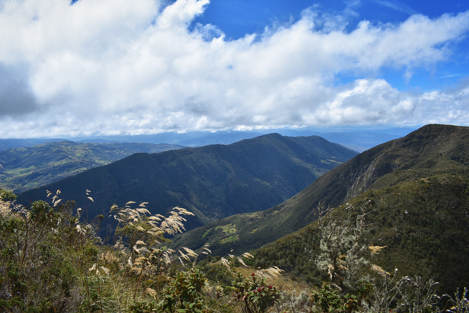
Section six takes you out of the forest and you can start to see the surrounding cerros. We were pretty anxious at the point as I was waiting to see a wall of rock that we would have to climb.


And then we arrived at the dreaded section 7 and I started laughing. My imagination had run wild but all I saw was a steep scramble up boulders. This steep climb lasts for 700 metres, which I will tell you now is no easy feat. But its not near impossible as I had been led to believe. I’m not sure that the photos do it justice but you start climbing at a very steep angle. First over small boulders and then the track turns to mud. I completly understand that people would find this section difficult and even dangerous on a wet day, today was not exactly a walk in the park, but keep pushing, rest, count your steps, catch your breath and you will make it up.


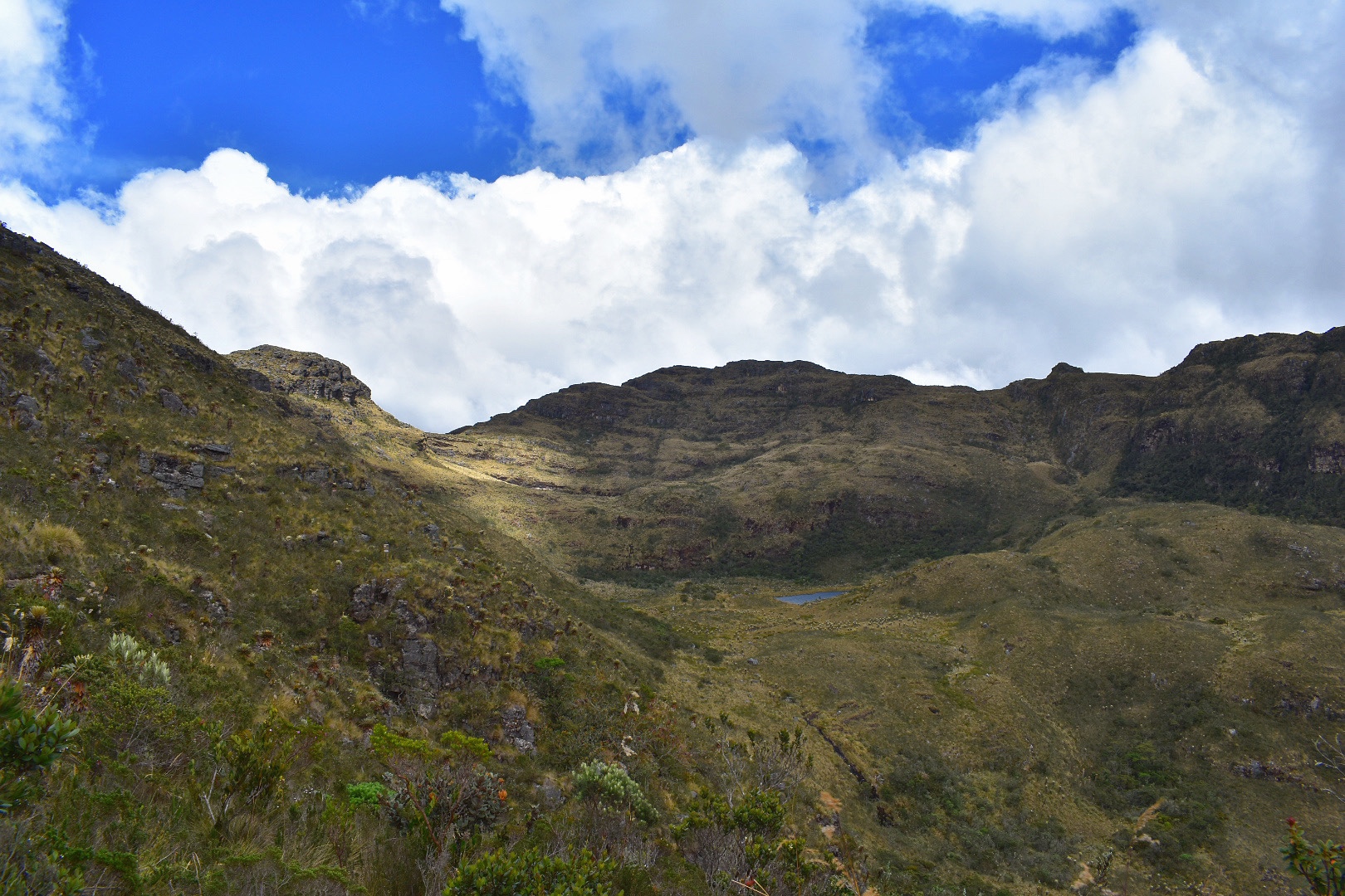
Almost immediately the views become stunning as you can see the surround valleys and mountains and more is revealed with each step.

We saw some interesting coloured insects and at this point you have reached the páramo where the plants take on a unique look.


And before you know it you reach the top. There are a few short climbs here but mostly this next section is flat. This is the highest altitude part of the trek so take it easy and just enjoy the view. Here you are on top of the world, well not quite but around the surrounding mountains. Enjoy as the hard work has now been done.


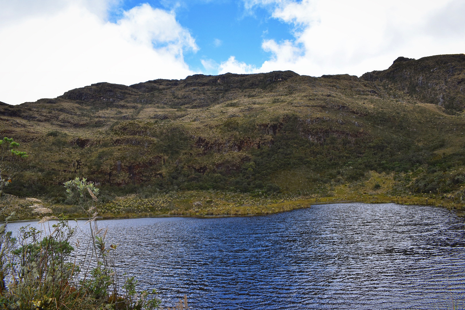
I was walking faster than Angela and so went a little ahead as she wanted to rest. I cam around a corner and then I saw the prize of the hike. The lake! It was pretty cloudy when I first arrived so I sat on a rock and dealt with the altitude while i waited for Angela to catch up, and in that time the clouds started to clear. I was excited as this entire time I had been unsure if we would reach the lake but now I could see it I was happy. When Angela arrived I suggested stopping but she was happy to push on and the next part of the hike down to the lake is largely downhill.


As we got closer still the skies became bluer still and the sun started casting shadows on the mountains.


When you reach the lake there is a feeling of something special. It was around 12:30pm at this time. There were only around 6 other people here and it was so peaceful and quiet. You could imagine the indigenous peoples believing the lake was special. And that is because it is.
We stopped here and had lunch. I’ve read that people do go further and climb the mountain behind the lake but this is now restricted and signs ask you not to go any further.


We waited around half an hour until around 1pm giving us three hours to get back to the bus. On the way back we still saw people coming to the lake and hoped they would make it down in time. The first part of the return journey is up which was tiring as we were already exhausted from the initial climb but after that the return journey is much quicker, although harder on the knees, as it is all downhill.


We took out time and stopped to rest on plenty of occasions on the way back down and made it to the entrance in around two hours. On the way we made a new friend who made up for the lack of dogs on this trail.


We spoke to the rangers to inform them that we had left, which is really important as they might otherwise go looking for you and had plenty of time to walk to the bus stop. We were enjoying the sunny afternoon when some of the other hikers stopped in their car and offered us a ride back to town. We took this opportunity to have a well earned rest and upon arriving headed to the bus station to take the bus back to Bogota. We were exhausted and would have stayed in town for another night if we didn’t have plans the next day.

From Bogotá to Villa de Leyva
Busses regularly leave Terminal Norte, which would be my recommended bus station. You can cake busses from the main terminal in Salitre, but these will al pass through Terminal Norte, so unless Salitre is on the way head straight to Terminal Norte. You can arrive here on the Transmileno or taxis are not too expensive.
The bus ticket is between $25000 and $28000 each way depending on which company you use. There are three, Libertadores, Omega and Valle de Tenza (Timetable), just check all the windows when you arrive and book the next bus. If you are travelling on the weekend make sure you arrive early as this is a weekend destination for people from Bogotá.
The journey will take between 2.5 – 3 hours, more so if the bus decides to stop in other towns, but will take you direct to the main bus station in town.
How to Hike Laguna de Iquaque
Its not possible to make this hike in one day from Bogotá so I advise that you stay a night in Villa de Leyva. There is a bus that leaves the main bus station each day at 7am and will drop you at Casa de Piedra returning to collect you at 4pm. It’s $4000 each way. When you arrive just ask for the bus to Parque Iquaque and after the laughter subsides you will be pointed to the bus.
Make sure you arrive early as there is only one bus each day and it can fill up, as it did for us and people flagging on the road did not get in. Also buy your return ticket when on the bus so that they save space for you. Its a long walk back if they can’t pick you up.
It take around 40 minutes to drive to the drop off point at Casa de Piedra and from here its a 2.5km walk along the track to the park entrance. It should take around 40 minutes and if you are offered insurance along the route at a snack store then make sure you buy for around $6000. It feels like a scam but it actually required and you don’t want to have to walk back.
Arriving at the park you will be met by the ranger who will give you some safety instructions, scare you about the difficulty of the hike and charge the entrance fee of $18500 for nationals and $52000 for gringos. You can find up to date prices for all Colombia’s parks here. There are flushing toilets here and make sure you take advantage of them as they will be the last you will see until you return to this point.
The hike is broken down into numbered sections. This works quite well until you reach section 7 and here is a map of the hike. Once you start on the trek its hard to get lost. Just stay on the path.
Its mostly uphill with one very steep section but take it slowly and you will be fine. Make sure you head back at 1pm as instructed to make the bus. It took us 3 hours to reach the top and then 2 hours to come back down, but you also need to factor in the extra 2.5km at the end to reach the bus.
Equipment to take
There is no food or water available once you get on the bus so make sure that you stock up the day before. There are supermarkets in town, a D1 and an Ara as well as numerous local businesses so prepare the day before. In addition to food and water I would recommend the following:
- Gortex hiking boots
- Waterproof jacket
- Waterproof trousers
- Dry bag or packback cover (I take both)
- Cell phone
- Cell phone battery
- Charger cable
- Sunglasses
- Sun Cream
- Painkillers
- Blister plasters (better if you have a small first aid kit)
- Hand soap
- Tissues
- Water filer
- Sun hat
- Food – you can never have too much and you will need it on this hike so pack appropriately.
- Water 3 litres minimum
Clothes
This is a high altitude hike which can get cold and also can often be wet so be prepared for the cold.
- Base layer
- Jumper
- Fleece
- Down Jacket
- Hiking trousers
- Hiking underwear
- Hiking socks

How to Hike to Mirador El Santo
There is a short 2 hour walk that will take you into the mountains above Villa de Leyva, its perfect to do in the afternoon the day before you hike to Laguna Iguaque. In total the walk is around two hours. Starting in Calle 12, head up towards the statue for 1km before enjoying the city and then heading back down again. Its a steep path with one little tricky section which shouldn’t cause too many problems. The route is on Maps.me if you need help finding the path.
There are lots of other things to do in Villa de Leyva so you can make a weekend trip or stay longer. For some suggestions check out this blog. Its also a big party town, most famous for the Kite Festival where Angela has fond but blurry memories drinking in the main square. You can find out more about the different festivals here.
For other hikes which you can combine with a weekend getaway take a look at my guides to Cerro Quininí, where the temperature is much warmer than Bogotá and you can relax in the surrounding coffee farms. Or head to Parque Natural Chicaque and spend the weekend camping, or relaxing in the hotel, while hiking,bird watching or horse riding.

Angela rocío Rodríguez Martínez
Excelente oportunidad para conocer nuestros legados